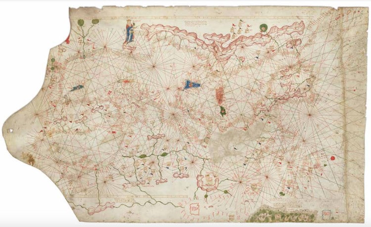
Over the last few years, we've heard about mind-boggling finds in thrift stores and estate sales. The tale always features someone spotting an unassuming work of art, taking it home, only to then realize it is worth much more than what they originally paid for it. As thrilling as those stories are, none come close to the 14th-century portolan chart that is now under the care of Barry Lawrence Ruderman Antique Maps Inc. Not only did it turn out to be significantly older and more valuable than originally thought, but it was also a museum-ready piece that can offer revolutionary insight into the history of maps.
“Portolan charts represent the birth of mapmaking as a modern person would understand it; that is, an attempt to visually represent geography with primary attention paid to spatial accuracy,” map dealer Alex Clausen, who spotted the map at an estate sale for Ann and Gordon Getty, tells My Modern Met. Thought to have been created around 1500 and 1525, Clausen and his team paid $239,000 for the map at a Christie's auction.
As for the valuation of the antique, there were some hints that pointed to the map being significantly older than its listing information indicated. “The chart had some obvious idiosyncrasies that made the date ascribed by the auction house very unlikely, if not impossible,” explains Clausen. “The first was the Muslim flag at Granada in southern Spain. This made it very likely that the chart was from before 1493. As we got better images, we saw more and more details that pushed the chart back earlier and earlier.”
To get to the bottom of this, Clausen and the team at Barry Lawrence Ruderman Antique Maps devoted hundreds of hours to unravel each element on the map. “The primary challenge was that we ended up in an era (the 14th century) where there is little in the way of cartographic context. There are only three earlier charts of this scope, in the decades after our chart was completed, there were similarly few charts. This makes comparison and contrast more difficult than if we were dealing with dozens or hundreds of maps.”
By the end of the journey, the team concluded that the map actually dated to 1360. “This is the fourth-oldest such chart, and it belongs to a unique and previously unstudied lineage of charts,” Clausen notes. “As such, it provides a revelatory window on the earliest modern mapmaking.” The portolan chart's estimated worth is now $7.5 million.
For all the ancient maps that they have come across, a portolan chart of such antiquity was something out of their wildest dreams. “We had long understood that it was possible that, in our careers, we would handle portolan charts from the 16th century, and, if we were very lucky, we might handle one from the 15th century,” shares Clausen. “Barry and I knew that handling a complete 14th-century chart was out of the question for modern map dealers. Such maps did not even appear in commerce 100-200 years ago when antiquarian treasures were somewhat more common, so, in the 21st century, there was little point in hoping to own such a thing. When we confidently established the chart's age, it was in many ways the culmination of our careers and our lifetime passions.”
But that's not the end of the road. Not only is the map unique, but, according to Clausen, it seems to sit outside of any previously known schools of mapmaking. Any one of the data points might influence future research. As such, their hope is for it to be further studied, and then shared with the world. “We intend to sell the chart to a suitable buyer,” Clausen shares. “We hope it goes to an institution or private collection where it will be available to scholars for further study and to the general public for appreciation.”
Map dealer Alex Clausen spotted an antique map known as a portolan chart during an estate sale. Thought to have been created around 1500 and 1525, Clausen and his team paid $239,000 for the map at a Christie's auction.

However, Clausen explains, “The chart had some obvious idiosyncrasies that made the date ascribed by the auction house very unlikely, if not impossible.”
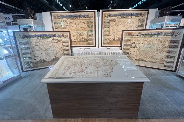
The Portolan Chart on display at the New York Antiquarian Book Fair. (Photo: Alex Clausen)
After hundreds of hours of research, the team concluded that the map actually dated to 1360. The portolan chart's estimated worth is now $7.5 million.
Barry Lawrence Ruderman Antique Maps Inc.: Website | Instagram | Facebook
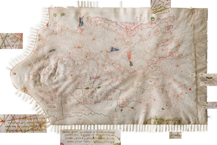
My Modern Met granted permission to feature photos by Barry Lawrence Ruderman Antique Maps Inc., except where noted. All images of the Portolan were captured by the BLR Maps Imaging Team through a series of 600 dpi scans, stitched raking-light photography and stitched photo-microscopy.
Related Articles:
This 19th-Century Atlas Has Raised Maps for Blind Readers
19th-Century Map Shows That Beaver Dams Can Last Over a Century
509-Year-Old Map Is the Only Known Copy of First Time “America” Appears
Cartographer Transforms Vintage Maps Into 3D Relief Maps Showing Elevation